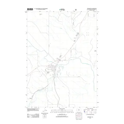
2012 Map of Edgemont
USGS Topo · Published 2012About this map
The Cheyenne River serves as the central geographic feature of this 2012 survey, winding past the town center of Edgemont and through a landscape of deeply cut drainages. The settlement pattern here is anchored by the convergence of major roads and local landmarks like the Edgemont Municipal Airport and the Edgemont Cem. This modern record reveals how transportation corridors like Harrison Rd and CO Hwy-6463 link the main town with satellite areas such as Dudley and Dennis. Local topography is defined by the significant ravines and heights that flank the river valley, including the imposing Breakneck Hill and the rugged stretches of Stone Quarry Canyon and Red Canyon. These named canyons and draws illustrate the complex water-carved terrain of Fall River County, where water bodies like Cottonwood Cr and Red Canyon Cr feed into the primary river system.
Find a feature on this map
30 named features on this map. Tap any name to fly to it.
Don’t see what you’re looking for? This feature index may not catch every label — zoom into the map to look around manually.
Map Details
Editions of this 2012 Edgemont Map
This is the sole edition of this map. No revisions or reprints were ever made.
Other maps of this area

1902 · Edgemont
USGS Topo · 1:125,000

1950 · Edgemont
USGS Topo · 1:24,000

1950 · Edgemont SW
USGS Topo · 1:24,000

1950 · Rumford
USGS Topo · 1:24,000

1950 · Burdock
USGS Topo · 1:24,000

1950 · Edgemont NE
USGS Topo · 1:24,000

1950 · Minnekahta
USGS Topo · 1:24,000

1950 · Flint Hill
USGS Topo · 1:24,000

1955 · Hot Springs
USGS Topo · 1:250,000
1982 · Provo
USGS Topo · 1:25,000