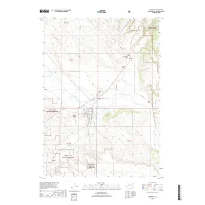
2017 Map of Edgemont
USGS Topo · Published 2017About this map
Edgemont serves as the central hub of this southwestern South Dakota landscape, situated along a prominent bend in the Cheyenne River. The settlement pattern follows the river valley, with the neighboring community of Dudley and the outlying site of Dennis connected by a network of rural routes like River Rd and Dewey Rd. This 2017 survey shows the town's detailed street grid, from A St to H St and out toward Grist Ave, adjacent to the Edgemont Municipal Airport. The surrounding terrain is defined by dramatic erosional features including Stone Quarry Canyon, Red Canyon, and Sheep Canyon. Significant public lands frame the township, with the Black Hills National Forest encroaching from the northeast and the expansive Buffalo Gap National Grassland covering much of the southern and western territory.
Find a feature on this map
43 named features on this map. Tap any name to fly to it.
Don’t see what you’re looking for? This feature index may not catch every label — zoom into the map to look around manually.
Map Details
Editions of this 2017 Edgemont Map
This is the sole edition of this map. No revisions or reprints were ever made.
Other maps of this area

1902 · Edgemont
USGS Topo · 1:125,000

1950 · Edgemont
USGS Topo · 1:24,000

1950 · Edgemont SW
USGS Topo · 1:24,000

1950 · Rumford
USGS Topo · 1:24,000

1950 · Burdock
USGS Topo · 1:24,000

1950 · Edgemont NE
USGS Topo · 1:24,000

1950 · Minnekahta
USGS Topo · 1:24,000

1950 · Flint Hill
USGS Topo · 1:24,000

1955 · Hot Springs
USGS Topo · 1:250,000
1982 · Provo
USGS Topo · 1:25,000