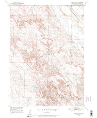
1950 Map of Edgemont SW
USGS Topo · Published 1952About this map
The Cheyenne River winds through this southwestern corner of Fall River County, shaping a landscape defined by water management and mid-century ranching. The Chicago Burlington and Quincy railroad tracks parallel the river's path, serving as the primary transit corridor through the Dudley area. Irrigation infrastructure is prominent, with the Tubbs Canal and an Irrigation Canal diverting water to the arid terrain, alongside an Abandoned Canal that suggests shifting agricultural efforts. Numerous drainage ways such as Agate Creek, Fiddle Creek, and Driftwood Creek carve through the Cottonwood hills, while scattered windmills and isolated wells indicate the vital importance of groundwater for the local livestock economy during the early 1950s.
Find a feature on this map
17 named features on this map. Tap any name to fly to it.
Don’t see what you’re looking for? This feature index may not catch every label — zoom into the map to look around manually.
Map Details
Editions of this 1950 Edgemont SW Map
2 editions found
Other maps of this area

1902 · Edgemont
USGS Topo · 1:125,000

1950 · Edgemont
USGS Topo · 1:24,000

1950 · Edgemont SW
USGS Topo · 1:24,000

1950 · Burdock
USGS Topo · 1:24,000

1950 · Edgemont NE
USGS Topo · 1:24,000

1951 · Twentyone Divide
USGS Topo · 1:24,000

1955 · Hot Springs
USGS Topo · 1:250,000

1955 · Newcastle
USGS Topo · 1:250,000

1958 · Newcastle
USGS Topo · 1:250,000

1978 · Coffee Flats
USGS Topo · 1:24,000