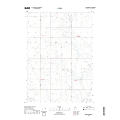
2019 Map of Edgerton North
USGS Topo · Published 2019About this map
Coteau des Prairies defines the rolling topography of this corner of Pipestone County, where the highlands of the prairie plateau give way to the drainage of the Rock River. Small agricultural settlements are spaced across a rigid section-line grid of rural roads, including 101st St and 21st St. The town of Edgerton occupies the southeastern corner of the map near Hillside Cem, serving as a focal point for the surrounding farming community. To the west, the village of Trosky is located near its namesake Trosky Cem, while the small cluster of Hatfield sits further north along the local rail alignment. This survey captures the enduring character of southwestern Minnesota's rural landscape, documenting the precise relationship between established town sites and the natural watercourses that shaped early settlement patterns.
Find a feature on this map
22 named features on this map. Tap any name to fly to it.
Don’t see what you’re looking for? This feature index may not catch every label — zoom into the map to look around manually.
Map Details
Editions of this 2019 Edgerton North Map
This is the sole edition of this map. No revisions or reprints were ever made.
Other maps of this area

1953 · Watertown
USGS Topo · 1:250,000

1955 · Sioux Falls
USGS Topo · 1:250,000

1958 · Sioux Falls
USGS Topo · 1:250,000

1958 · Watertown
USGS Topo · 1:250,000

1967 · Edgerton South
USGS Topo · 1:24,000

1967 · Pipestone North
USGS Topo · 1:24,000

1967 · Edgerton North
USGS Topo · 1:24,000

1967 · Edgerton NE
USGS Topo · 1:24,000

1967 · Kenneth
USGS Topo · 1:24,000
1967 · Woodstock
USGS Topo · 1:24,000