
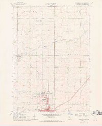
1967 Map of Pipestone North
USGS Topo · Published 1968About this map
Pipestone National Monument anchors the southern portion of this landscape, preserving the cultural and geological significance of the red catlinite quarries. In the late 1960s, this area was a critical junction for Upper Midwest transit, where the Chicago Milwaukee St Paul and Pacific, the Great Northern, and the Chicago Rock Island and Pacific railroads converged near the Pipestone city limits. The terrain is defined by the winding course of Pipestone Creek and its northern and southern branches, punctuated by landmarks like Winnewissa Falls and Indian Lake. Rural life is marked by numerous Gravel Pits and public works including a Vocational Sch and several cemeteries such as Woodlawn Cem and Troy Cem. The map captures the agricultural and industrial character of the Pipestone area before the further consolidation of the rail lines that once powered this prairie economy.
Find a feature on this map
40 named features on this map. Tap any name to fly to it.
Don’t see what you’re looking for? This feature index may not catch every label — zoom into the map to look around manually.
Map Details
Editions of this 1967 Pipestone North Map
2 editions found
Other maps of this area

1953 · Watertown
USGS Topo · 1:250,000

1955 · Sioux Falls
USGS Topo · 1:250,000

1958 · Sioux Falls
USGS Topo · 1:250,000

1958 · Watertown
USGS Topo · 1:250,000

1967 · Edgerton North
USGS Topo · 1:24,000

1967 · Ruthton NW
USGS Topo · 1:24,000

1967 · Elkton SW
USGS Topo · 1:24,000

1967 · Verdi
USGS Topo · 1:24,000

1967 · Pipestone South
USGS Topo · 1:24,000

1967 · Jasper NW
USGS Topo · 1:24,000