
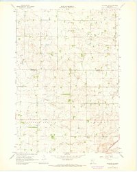
1967 Map of Ruthton NW
USGS Topo · Published 1968About this map
Fountain Prairie and Aetna townships define the southern reaches of this landscape in the late 1960s, where the headwaters of the Redwood River and Pipestone Cr Br begin their journey through the glacial till. The terrain is a structured grid of agricultural sections, marked by a systematic drainage network including Ditch No 7, Ditch No 2, and Ditch No 16. These managed waterways reflect the transformation of the prairie into productive farmland during the mid-20th century.
Find a feature on this map
14 named features on this map. Tap any name to fly to it.
Don’t see what you’re looking for? This feature index may not catch every label — zoom into the map to look around manually.
Map Details
Editions of this 1967 Ruthton NW Map
2 editions found
Other maps of this area

1953 · Watertown
USGS Topo · 1:250,000

1958 · Watertown
USGS Topo · 1:250,000

1963 · Dead Coon Lake
USGS Topo · 1:24,000

1963 · Tyler
USGS Topo · 1:24,000

1967 · Pipestone North
USGS Topo · 1:24,000
1967 · Ruthton
USGS Topo · 1:24,000
1967 · Woodstock
USGS Topo · 1:24,000

1967 · Verdi
USGS Topo · 1:24,000

1967 · Lake Benton
USGS Topo · 1:24,000
1967 · Holland
USGS Topo · 1:24,000