
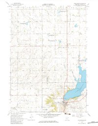
1967 Map of Lake Benton
USGS Topo · Published 1968About this map
Lake Benton serves as the focal point for this survey of southwestern Minnesota, where the township and its namesake lake meet at a vital crossroads. The Chicago and North Western railroad skirts the southern shore, anchoring the local economy to the grain and transport networks of the late 1960s. Local landmarks such as the High Sch and Memorial Cemetery illustrate the established civic life of the community.
Find a feature on this map
31 named features on this map. Tap any name to fly to it.
Don’t see what you’re looking for? This feature index may not catch every label — zoom into the map to look around manually.
Map Details
Editions of this 1967 Lake Benton Map
2 editions found
Other maps of this area

1953 · Watertown
USGS Topo · 1:250,000

1958 · Watertown
USGS Topo · 1:250,000

1963 · Tyler
USGS Topo · 1:24,000

1963 · Arco
USGS Topo · 1:24,000

1967 · Ruthton NW
USGS Topo · 1:24,000

1967 · Verdi
USGS Topo · 1:24,000

1967 · Lake Benton NW
USGS Topo · 1:24,000

1967 · Lake Benton SW
USGS Topo · 1:24,000

1967 · Lake Benton NE
USGS Topo · 1:24,000

1967 · Elkton
USGS Topo · 1:24,000