
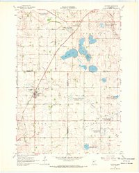
1963 Map of Tyler
USGS Topo · Published 1964About this map
The prairie landscape of Tyler is defined by a dense network of water management and rail infrastructure typical of southwestern Minnesota. The Chicago and North Western railroad bisects the terrain, serving as the primary corridor for the community and its local industry. Large glacial lakes, including Lake Benton at an elevation of 1746 feet and the northern Ash Lake, dominate the topography. These natural basins are supplemented by an extensive system of engineered waterways such as County Ditch No 4 and Judicial Ditch No 30. The map reveals the mid-century social and civic layout of the town, featuring the Danebod Cem, a local Hospital, and the Fairground. Recreational and modern amenities of the early 1960s are also evident, including a Drive-in Theater and the Tyler Municipal Airport.
Find a feature on this map
25 named features on this map. Tap any name to fly to it.
Don’t see what you’re looking for? This feature index may not catch every label — zoom into the map to look around manually.
Map Details
Editions of this 1963 Tyler Map
This is the sole edition of this map. No revisions or reprints were ever made.
Other maps of this area

1953 · Watertown
USGS Topo · 1:250,000

1958 · Watertown
USGS Topo · 1:250,000

1963 · Dead Coon Lake
USGS Topo · 1:24,000

1963 · Gislason Lake
USGS Topo · 1:24,000

1963 · Arco
USGS Topo · 1:24,000
1967 · Ruthton
USGS Topo · 1:24,000

1967 · Ruthton NW
USGS Topo · 1:24,000

1967 · Verdi
USGS Topo · 1:24,000

1967 · Lake Benton
USGS Topo · 1:24,000

1967 · Lake Benton NE
USGS Topo · 1:24,000