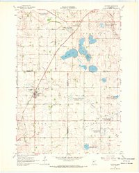
1967 Map of Ruthton
USGS Topo · Published 1968About this map
Ruthton and Florence serve as the primary rail-connected hubs in this 1960s landscape, positioned along the Great Northern railroad line. The map highlights a region transitioning between agricultural use and protected natural spaces, evidenced by numerous conservation areas like the Hope State Wildlife Management Area and the Ruthton State Wildlife Management Areas. Water management is a defining characteristic of the terrain, with an extensive network of drainage channels including Judicial Ditch No 14 and County Ditch No 16 crisscrossing the townships of Hope, Shelburne, Aetna, and Ellsborough. Notable hydrologic features such as West Twin Lake, East Twin Lake, and the winding Redwood River are captured alongside the dry Ivadelle Lakebed, illustrating the complex prairie pothole geography of the Minnesota borderlands during this era.
Find a feature on this map
33 named features on this map. Tap any name to fly to it.
Don’t see what you’re looking for? This feature index may not catch every label — zoom into the map to look around manually.
Map Details
Editions of this 1967 Ruthton Map
This is the sole edition of this map. No revisions or reprints were ever made.
Other maps of this area

1953 · Watertown
USGS Topo · 1:250,000

1953 · New Ulm
USGS Topo · 1:250,000

1957 · New Ulm
USGS Topo · 1:250,000

1958 · New Ulm
USGS Topo · 1:250,000

1958 · Watertown
USGS Topo · 1:250,000

1963 · Dead Coon Lake
USGS Topo · 1:24,000

1963 · Russell
USGS Topo · 1:24,000

1963 · Tyler
USGS Topo · 1:24,000

1967 · New Ulm
USGS Topo · 1:250,000

1967 · Ruthton NW
USGS Topo · 1:24,000