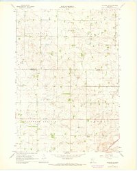
1967 Map of Ruthton NW
USGS Topo · Published 1968About this map
The agricultural plateaus of Fountain Prairie and Aetna townships define this mid-century landscape on the border of Lincoln and Pipestone Counties. Surveyed in 1965 and field-checked in 1967, the map shows a highly managed water system dominated by industrial-scale drainage projects like County Ditch No 2 and County Ditch No 16, which feed into the Redwood River. A single Townhall stands as a civic landmark in the southwestern corner, reflecting the sparse, decentralized settlement pattern typical of the era's farming communities.
Find a feature on this map
15 named features on this map. Tap any name to fly to it.
Don’t see what you’re looking for? This feature index may not catch every label — zoom into the map to look around manually.
Map Details
Editions of this 1967 Ruthton NW Map
2 editions found
Other maps of this area

1953 · Watertown
USGS Topo · 1:250,000

1958 · Watertown
USGS Topo · 1:250,000

1963 · Dead Coon Lake
USGS Topo · 1:24,000

1963 · Tyler
USGS Topo · 1:24,000

1967 · Pipestone North
USGS Topo · 1:24,000
1967 · Ruthton
USGS Topo · 1:24,000

1967 · Ruthton NW
USGS Topo · 1:24,000
1967 · Woodstock
USGS Topo · 1:24,000

1967 · Verdi
USGS Topo · 1:24,000

1967 · Lake Benton
USGS Topo · 1:24,000