
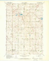
1967 Map of Edgerton North
USGS Topo · Published 1968About this map
Hatfield and the northern outskirts of Edgerton anchor this 1960s agricultural landscape in Pipestone County. The Chicago Milwaukee St Paul and Pacific railroad cuts diagonally across the terrain, serving as a primary corridor for the movement of goods through the townships of Gray, Burke, Elmer, and Osborne. This survey captures the rural infrastructure of the era, from the numerous Gravel Pits supporting local road work to the managed conservation lands at the Burke State Wildlife Management Area. Waterways like the East Branch Rock River and Rock River wind through the sections, often flanked by benchmarks and bridges such as BR 1596. For those researching family history, the map includes the locations of Trosky Cem and Hillside Cem, providing essential markers of local settlement and community heritage.
Find a feature on this map
26 named features on this map. Tap any name to fly to it.
Don’t see what you’re looking for? This feature index may not catch every label — zoom into the map to look around manually.
Map Details
Editions of this 1967 Edgerton North Map
This is the sole edition of this map. No revisions or reprints were ever made.
Other maps of this area

1953 · Watertown
USGS Topo · 1:250,000

1955 · Sioux Falls
USGS Topo · 1:250,000

1958 · Sioux Falls
USGS Topo · 1:250,000

1958 · Watertown
USGS Topo · 1:250,000

1967 · Edgerton South
USGS Topo · 1:24,000

1967 · Pipestone North
USGS Topo · 1:24,000

1967 · Edgerton NE
USGS Topo · 1:24,000

1967 · Kenneth
USGS Topo · 1:24,000
1967 · Woodstock
USGS Topo · 1:24,000

1967 · Jasper SE
USGS Topo · 1:24,000