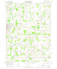
1961 Map of Edgerton
USGS Topo · Published 1974About this map
Edgerton stands as the primary hub of this 1960s agricultural landscape, situated where the St Joseph River meets the Penn Central railroad tracks. The map captures a moment of infrastructure evolution, documenting revisions through 1973 that reflect changes in the area’s rural character. Beyond the main village, smaller communities like Melbern, Mina, and Farmer anchor the surrounding townships of St Joseph, Center, Milford, and Farmer.
Find a feature on this map
32 named features on this map. Tap any name to fly to it.
Don’t see what you’re looking for? This feature index may not catch every label — zoom into the map to look around manually.
Map Details
Editions of this 1961 Edgerton Map
3 editions found
Other maps of this area

1914 · Pioneer
USGS Topo · 1:62,500

1914 · Bryan
USGS Topo · 1:62,500

1940 · Metz
USGS Topo · 1:24,000

1943 · Bryan
USGS Topo · 1:62,500

1944 · Pioneer
USGS Topo · 1:62,500

1953 · Fort Wayne
USGS Topo · 1:250,000

1956 · Fort Wayne
USGS Topo · 1:250,000

1958 · Hicksville
USGS Topo · 1:24,000

1958 · Butler East
USGS Topo · 1:24,000

1960 · Sherwood
USGS Topo · 1:24,000