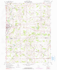
1961 Map of Edgerton
USGS Topo · Published 1990About this map
The St Joseph River meanders through the northwest corner of this corner of Williams and Defiance Counties, where the village of Edgerton serves as a primary rail hub along the Penn Central line. This landscape, surveyed in the early 1960s, reflects a stable agricultural and transport corridor defined by the boundary between St Joseph and Center townships. Small rail stops and hamlets like Mina and Melbern mark the track's path eastward, while the southern reaches near the border of Milford and Farmer townships transition into a drainage network of Crooked Creek and Dry Creek. Genealogists will find several rural landmarks including Tamarack Cem, Bethel Cem, and Emanuel Ch. The presence of several Gravel Pit operations and the Pumping Station near the pipeline indicates the localized industrial activity supporting the regional infrastructure during this era.
Find a feature on this map
35 named features on this map. Tap any name to fly to it.
Don’t see what you’re looking for? This feature index may not catch every label — zoom into the map to look around manually.
Map Details
Editions of this 1961 Edgerton Map
3 editions found
Other maps of this area

1914 · Pioneer
USGS Topo · 1:62,500

1914 · Bryan
USGS Topo · 1:62,500

1940 · Metz
USGS Topo · 1:24,000

1943 · Bryan
USGS Topo · 1:62,500

1944 · Pioneer
USGS Topo · 1:62,500

1953 · Fort Wayne
USGS Topo · 1:250,000

1956 · Fort Wayne
USGS Topo · 1:250,000

1958 · Hicksville
USGS Topo · 1:24,000

1958 · Butler East
USGS Topo · 1:24,000

1960 · Sherwood
USGS Topo · 1:24,000