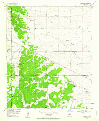
1954 Map of Edgewood
USGS Topo · Published 1963About this map
Edgewood and the nearby settlement of Barton occupy a high-desert plateau where Santa Fe, Bernalillo, and Torrance counties meet. This mid-century landscape is defined by extensive ranching operations and family holdings, including Hill Ranch, Bassett Ranch, and the Bella Vista Ranch. A prominent Old Railroad Grade cuts across the northeastern terrain, marking a former transportation corridor that once linked these high plains to larger markets. The map reveals a transition from the wooded elevations of Tomas Canyon to the drainage systems of Bachelor Draw and the Arroyo de San Jose. Local life is anchored by landmarks such as the Mountain Valley Cemetery and the high point at VABM 7003 Northam, while numerous windmills scattered across the quadrangle highlight the essential role of water management in this arid environment.
Find a feature on this map
30 named features on this map. Tap any name to fly to it.
Don’t see what you’re looking for? This feature index may not catch every label — zoom into the map to look around manually.
Map Details
Editions of this 1954 Edgewood Map
3 editions found
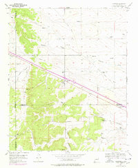
Other maps of this area

1892 · San Pedro
USGS Topo · 1:125,000

1917 · Estancia
USGS Topo · 1:125,000

1954 · Chilili
USGS Topo · 1:24,000

1954 · Sandia Park
USGS Topo · 1:24,000

1954 · San Pedro
USGS Topo · 1:24,000

1954 · Sedillo
USGS Topo · 1:24,000

1954 · Escabosa
USGS Topo · 1:24,000

1954 · Edgewood
USGS Topo · 1:24,000

1954 · Socorro
USGS Topo · 1:250,000

1956 · Edgewood
USGS Topo · 1:62,500