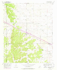
1954 Map of Edgewood
USGS Topo · Published 1978About this map
Edgewood serves as the focal point of this high-desert landscape where the borders of Bernalillo, Santa Fe, and Torrance counties converge. The mapping captures a distinct ranching economy, documented through numerous family-named homesteads such as Bella Vista Ranch, Lacy Place, and Briggs Place. The presence of an Old Railroad Grade and a prominent Telephone Line cutting diagonally across the terrain reflects the transportation and communication corridors that historically connected these high-altitude settlements.
Find a feature on this map
35 named features on this map. Tap any name to fly to it.
Don’t see what you’re looking for? This feature index may not catch every label — zoom into the map to look around manually.
Map Details
Editions of this 1954 Edgewood Map
3 editions found
Other maps of this area

1892 · San Pedro
USGS Topo · 1:125,000

1917 · Estancia
USGS Topo · 1:125,000

1954 · Chilili
USGS Topo · 1:24,000

1954 · Sandia Park
USGS Topo · 1:24,000

1954 · San Pedro
USGS Topo · 1:24,000

1954 · Sedillo
USGS Topo · 1:24,000

1954 · Escabosa
USGS Topo · 1:24,000

1954 · Edgewood
USGS Topo · 1:24,000

1954 · Socorro
USGS Topo · 1:250,000

1956 · Edgewood
USGS Topo · 1:62,500