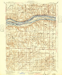
1916 Map of Edgington
USGS Topo · Published 1942About this map
The Mississippi River dominates this mid-20th century survey, carving a path between Rock Island County and Muscatine County through a complex network of backwaters like Andalusia Slough and Vealey Chute. Steep bluffs rise from the river valley, leading to high prairie settlements and an unusually high density of rural schoolhouses that served the farming communities of the early 1900s. Illinois City and Edgington stand as primary inland hubs, while the river banks host rail-dependent hamlets such as Fairport and Montpelier.
Find a feature on this map
78 named features on this map. Tap any name to fly to it.
Don’t see what you’re looking for? This feature index may not catch every label — zoom into the map to look around manually.
Map Details
Editions of this 1916 Edgington Map
3 editions found

Other maps of this area

1890 · Durant
USGS Topo · 1:62,500

1891 · Davenport
USGS Topo · 1:62,500

1891 · Wilton Junction
USGS Topo · 1:62,500

1894 · Durant
USGS Topo · 1:62,500

1894 · Davenport
USGS Topo · 1:62,500

1901 · Rock Island
USGS Topo · 1:125,000

1901 · Stanwood
USGS Topo · 1:125,000

1910 · Rock Island
USGS Topo · 1:125,000

1912 · Milan
USGS Topo · 1:62,500

1916 · Edgington
USGS Topo · 1:62,500