
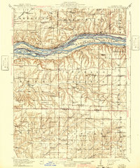
1916 Map of Edgington
USGS Topo · Published 1916About this map
Mississippi River islands and braided sloughs dominate the northern corridor of this 1913 survey, where the Chicago Milwaukee and St Paul railroad tracks skirt the riverbank. This era of rural development is marked by a dense network of country schools, such as Whiteoak School, Patterson School, and Point Pleasant School, positioned to serve the farming families across Buffalo Prairie and Eliza. The landscape transitions from the river bottomlands at Vealey Chute and Andalusia Slough to the upland plains of Edgington.
Find a feature on this map
78 named features on this map. Tap any name to fly to it.
Don’t see what you’re looking for? This feature index may not catch every label — zoom into the map to look around manually.
Map Details
Editions of this 1916 Edgington Map
3 editions found
Other maps of this area

1890 · Durant
USGS Topo · 1:62,500

1891 · Davenport
USGS Topo · 1:62,500

1891 · Wilton Junction
USGS Topo · 1:62,500

1894 · Durant
USGS Topo · 1:62,500

1894 · Davenport
USGS Topo · 1:62,500

1901 · Rock Island
USGS Topo · 1:125,000

1901 · Stanwood
USGS Topo · 1:125,000

1910 · Rock Island
USGS Topo · 1:125,000

1912 · Milan
USGS Topo · 1:62,500

1916 · Edgington
USGS Topo · 1:62,500