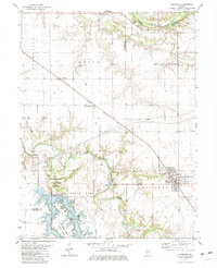
1982 Map of Edinburg
USGS Topo · Published 1983About this map
The South Fork Sangamon River and the expansive Sangchris Lake define the geography of this central Illinois landscape. In the early 1980s, the area reflects a complex mix of recreation and resource extraction, with Sangchris Lake State Park offering numerous picnic areas and a boat ramp alongside active energy production. The Roby Oil Field and scattered oil wells across the Field and East Field sections indicate the subterranean industrial value of the region. The village of Edinburg serves as a local hub, connected by the Baltimore and Ohio railroad which cuts diagonally across the terrain through Breckenridge and Berry. Genealogists will find several burial grounds preserved, including Oak Hill Cem, Furrow Cem, and Taylor Cem, documenting the long-standing rural communities of Buckhart and Rochester townships.
Find a feature on this map
37 named features on this map. Tap any name to fly to it.
Don’t see what you’re looking for? This feature index may not catch every label — zoom into the map to look around manually.
Map Details
Editions of this 1982 Edinburg Map
This is the sole edition of this map. No revisions or reprints were ever made.
Other maps of this area

1907 · Springfield
USGS Topo · 1:62,500

1922 · Divernon
USGS Topo · 1:62,500

1923 · Taylorville
USGS Topo · 1:62,500

1924 · Divernon
USGS Topo · 1:62,500

1925 · Taylorville
USGS Topo · 1:62,500

1930 · Springfield
USGS Topo · 1:62,500

1940 · Springfield
USGS Topo · 1:62,500

1950 · Springfield East
USGS Topo · 1:24,000

1954 · Mechanicsburg
USGS Topo · 1:62,500

1958 · Decatur
USGS Topo · 1:250,000