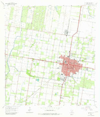
1963 Map of Edinburg
USGS Topo · Published 1981About this map
The irrigation-driven landscape of the Rio Grande Valley is clearly visible in this 1960s survey, dominated by the grid of Edinburg Main Canal, North Canal, and Santa Cruz Canal. The city of Edinburg functions as a regional hub, serving as the seat of local government with the Court House and City Hall at its center. The map documents a period of academic and religious growth, featuring the sprawling Pan American College campus and various parochial institutions like Sacred Heart Sch (Church) and the Rio Grande Bible Institute.
Find a feature on this map
44 named features on this map. Tap any name to fly to it.
Don’t see what you’re looking for? This feature index may not catch every label — zoom into the map to look around manually.
Map Details
Editions of this 1963 Edinburg Map
3 editions found
Other maps of this area

1914 · San Juan
USGS Topo · 1:48,000

1916 · San Juan
USGS Topo · 1:62,500

1940 · Monte Christo
USGS Topo · 1:62,500

1949 · Mc Allen
USGS Topo · 1:250,000

1954 · McAllen
USGS Topo · 1:250,000

1957 · Mc Allen
USGS Topo · 1:250,000

1962 · McAllen
USGS Topo · 1:250,000

1963 · Monte Christo
USGS Topo · 1:24,000
1963 · Hargill
USGS Topo · 1:24,000

1963 · Edinburg
USGS Topo · 1:24,000
Featured Places
- McAllen, TX
- Edinburg, TX
- Pharr, TX
- Citrus City Lake Number 1 Colonia, TX
- Evangeline Gardens Colonia, Edinburg