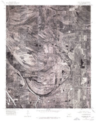
1975 Map of Edmondson NW
USGS Topo · Published 1976About this map
Blackfish Bayou winds through the heart of this alluvial landscape in Crittenden County, revealing the complex drainage and agricultural patterns of the Arkansas Delta in the mid-1970s. This orthophoto map provides a clear look at the large-scale farming operations and the intricate network of field divisions that defined the area during this era. Small rural clusters and junctions such as Hanover and Felco dot the northern portion of the map, while the southern section is anchored by Shearerville and the settlement of Dixie. The distinctive crescent of Shell Lake in the southwest corner serves as a notable landmark, illustrating the region's characteristic oxbow formations. This survey is particularly useful for researchers tracing the evolution of Delta land use and identifying local landmarks and homesteads before significant late-twentieth-century changes.
Find a feature on this map
7 named features on this map. Tap any name to fly to it.
Don’t see what you’re looking for? This feature index may not catch every label — zoom into the map to look around manually.
Map Details
Editions of this 1975 Edmondson NW Map
This is the sole edition of this map. No revisions or reprints were ever made.
Other maps of this area

1939 · Edmondson
USGS Topo · 1:62,500

1940 · Deckerville
USGS Topo · 1:62,500

1940 · Princedale
USGS Topo · 1:62,500

1940 · Whitmore
USGS Topo · 1:62,500

1953 · Memphis
USGS Topo · 1:250,000

1954 · Edmondson
USGS Topo · 1:62,500

1956 · Memphis
USGS Topo · 1:250,000

1956 · Whitmore
USGS Topo · 1:62,500

1956 · Princedale
USGS Topo · 1:62,500

1957 · Deckerville
USGS Topo · 1:62,500