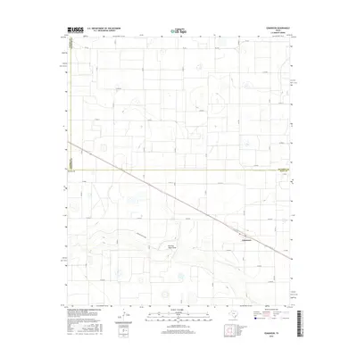
2016 Map of Edmonson
USGS Topo · Published 2016About this map
Edmonson serves as the primary hub for this agricultural portion of the Texas Panhandle, situated near the intersection of several farm-to-market routes. The landscape is defined by the ephemeral flow of Running Water Draw and Running River Draw, which cut through the level plains and provide a rare hydrological structure to the grid of section roads. The map documents a dense network of county roads, such as Co RD BB and Co RD 10, that facilitate the transport of crops and livestock through Hale County. Along the northern edge, the boundary between Castro and Swisher counties meets the Hale County line, marking a point where three major regional jurisdictions converge. Local streets like W 1st St and E 1st St define the small-scale development within the town site.
Find a feature on this map
35 named features on this map. Tap any name to fly to it.
Don’t see what you’re looking for? This feature index may not catch every label — zoom into the map to look around manually.
Map Details
Editions of this 2016 Edmonson Map
This is the sole edition of this map. No revisions or reprints were ever made.
Other maps of this area

1954 · Plainview
USGS Topo · 1:250,000

1954 · Clovis
USGS Topo · 1:250,000

1958 · Clovis
USGS Topo · 1:250,000

1958 · Plainview
USGS Topo · 1:250,000
1965 · Hart
USGS Topo · 1:24,000
1965 · Edmonson NE
USGS Topo · 1:24,000
1965 · Kress West
USGS Topo · 1:24,000
1965 · Edmonson
USGS Topo · 1:24,000
1965 · Hilburn
USGS Topo · 1:24,000
1965 · Center Plains School
USGS Topo · 1:24,000