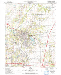
1991 Map of Edwardsville
USGS Topo · Published 1991About this map
Edwardsville and Glen Carbon serve as the primary hubs of development on this Madison County landscape as it appeared in the early 1990s. The topographic detail captures the sprawling campus of Southern Illinois University at Edwardsville at the western edge, along with the industrial and residential corridors that define the two municipalities. Traces of the region's older rural character remain visible in the outlying areas, particularly through the numerous family and denominational cemeteries like St James Cem and Woodlawn Cem.
Find a feature on this map
72 named features on this map. Tap any name to fly to it.
Don’t see what you’re looking for? This feature index may not catch every label — zoom into the map to look around manually.
Map Details
Editions of this 1991 Edwardsville Map
This is the sole edition of this map. No revisions or reprints were ever made.
Other maps of this area

1888 · St. Louis
USGS Topo · 1:62,500

1907 · Belleville
USGS Topo · 1:62,500

1927 · Alton
USGS Topo · 1:62,500

1927 · Edwardsville
USGS Topo · 1:62,500

1932 · Edwardsville
USGS Topo · 1:62,500

1934 · Alton
USGS Topo · 1:62,500

1935 · Monks Mound
USGS Topo · 1:24,000

1937 · Collinsville
USGS Topo · 1:24,000

1948 · Wood River
USGS Topo · 1:24,000

1949 · Saint Louis
USGS Topo · 1:250,000