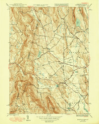
1948 Map of Egremont
USGS Topo · Published 1948About this map
North Egremont and South Egremont anchor this mid-century survey of the Berkshire valley where the Massachusetts border meets New York. The landscape transitions from the agricultural flats of Egremont Plain to the steep eastern slopes of the Taconic Range, dominated by peaks like Mt Fray and Mt Whitbeck. The water network of the Green River and Seekonk River defines the drainage of the region, supporting local industries indicated by Mill Pond and several reservoirs.
Find a feature on this map
66 named features on this map. Tap any name to fly to it.
Don’t see what you’re looking for? This feature index may not catch every label — zoom into the map to look around manually.
Map Details
Editions of this 1948 Egremont Map
3 editions found
Other maps of this area

1885 · Sheffield
USGS Topo · 1:62,500

1888 · Sheffield
USGS Topo · 1:62,500

1888 · Pittsfield
USGS Topo · 1:62,500

1890 · Pittsfield
USGS Topo · 1:62,500

1891 · Sheffield
USGS Topo · 1:62,500

1893 · Sheffield
USGS Topo · 1:62,500

1893 · Pittsfield
USGS Topo · 1:62,500

1894 · Pittsfield
USGS Topo · 1:62,500

1897 · Pittsfield
USGS Topo · 1:62,500

1897 · Sheffield
USGS Topo · 1:62,500