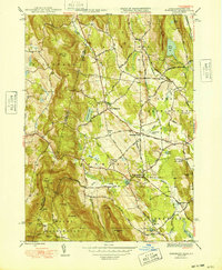
1948 Map of Egremont
USGS Topo · Published 1948About this map
The Egremont valley and its surrounding Berkshires peaks are captured here in the late 1940s, showing a landscape defined by small agrarian settlements and early aviation. North Egremont and South Egremont serve as the primary hubs, connected by the North Egremont Road and flanked by the Green River. Along the valley floor, the Great Barrington Airport and the Wyantenuck Golf Course mark the transition toward leisure and regional transportation.
Find a feature on this map
60 named features on this map. Tap any name to fly to it.
Don’t see what you’re looking for? This feature index may not catch every label — zoom into the map to look around manually.
Map Details
Editions of this 1948 Egremont Map
3 editions found
Other maps of this area

1885 · Sheffield
USGS Topo · 1:62,500

1888 · Sheffield
USGS Topo · 1:62,500

1888 · Pittsfield
USGS Topo · 1:62,500

1890 · Pittsfield
USGS Topo · 1:62,500

1891 · Sheffield
USGS Topo · 1:62,500

1893 · Sheffield
USGS Topo · 1:62,500

1893 · Pittsfield
USGS Topo · 1:62,500

1894 · Pittsfield
USGS Topo · 1:62,500

1897 · Pittsfield
USGS Topo · 1:62,500

1897 · Sheffield
USGS Topo · 1:62,500