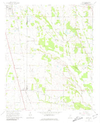
1965 Map of Egypt
USGS Topo · Published 1981About this map
Egypt and the southern outskirts of Okolona anchor this mid-century survey of the borderlands between Chickasaw and Monroe counties. The landscape is defined by the heavy drainage of Mattubby Creek and its many tributaries, including Massey Creek and Sudler Creek. A prominent Old Railroad Grade runs parallel to the active Gulf Mobile and Ohio tracks, tracing a former corridor of transit through the rural countryside. The map reveals a deeply rooted community structure, evidenced by the high density of small rural burial grounds and places of worship such as Walker Cem, Word Cem, and Darden Chapel. Aviation footprints are also visible at the Leuth Landing Strip and Ball Landing Field, serving as localized transport hubs amidst the agricultural fields and bottomlands near Cedar Creek.
Find a feature on this map
32 named features on this map. Tap any name to fly to it.
Don’t see what you’re looking for? This feature index may not catch every label — zoom into the map to look around manually.
Map Details
Editions of this 1965 Egypt Map
2 editions found
Other maps of this area

1953 · West Point
USGS Topo · 1:250,000

1956 · Tupelo
USGS Topo · 1:250,000

1958 · Tupelo
USGS Topo · 1:250,000

1958 · West Point
USGS Topo · 1:250,000

1959 · Van Vleet
USGS Topo · 1:62,500

1963 · West Point
USGS Topo · 1:250,000

1965 · Egypt
USGS Topo · 1:24,000

1966 · Aberdeen
USGS Topo · 1:24,000

1966 · Shannon
USGS Topo · 1:24,000

1966 · Wren
USGS Topo · 1:24,000