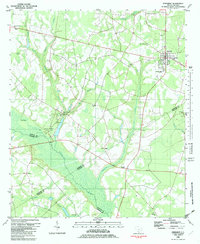
1982 Map of Ehrhardt
USGS Topo · Published 1983About this map
The Salkehatchie River wetlands dominate this Lowcountry landscape, forming a complex natural boundary where four counties—Bamberg, Allendale, Colleton, and Hampton—meet. In the early 1980s, the town of Ehrhardt serves as the primary hub, showing a grid of streets and the S C L railroad line passing through its center. Significant local history is preserved at Rivers Bridge State Park, which includes a Museum and Campground along the river banks. The area is dotted with numerous rural congregations and family burial grounds, such as Kearse-Brabham Cem and St Lukes Ch, reflecting a deeply rooted community structure. The map also captures the transition from dense swampland to agricultural clearings, with named water bodies like Threemile Creek and Savannah Creek feeding into the main river system near the small settlement of Jennys.
Find a feature on this map
41 named features on this map. Tap any name to fly to it.
Don’t see what you’re looking for? This feature index may not catch every label — zoom into the map to look around manually.
Map Details
Editions of this 1982 Ehrhardt Map
This is the sole edition of this map. No revisions or reprints were ever made.
Other maps of this area

1918 · Varnville
USGS Topo · 1:62,500

1919 · Olar
USGS Topo · 1:62,500

1919 · Cummings
USGS Topo · 1:62,500

1919 · Lodge
USGS Topo · 1:62,500

1920 · Lodge
USGS Topo · 1:48,000

1921 · Lodge
USGS Topo · 1:62,500

1943 · Olar
USGS Topo · 1:62,500

1943 · Lodge
USGS Topo · 1:62,500

1943 · Orangeburg
USGS Topo · 1:125,000

1943 · Cummings
USGS Topo · 1:62,500