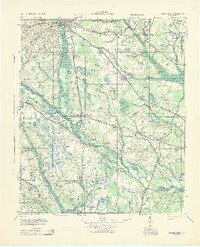
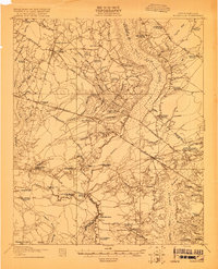
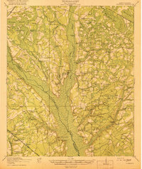
1943 Map of Orangeburg
USGS Topo · Published 1943About this map
The North Fork Edisto River and South Fork Edisto River converge near Branchville, forming a landscape defined by expansive wetlands like Four Hole Swamp and Indian Field Swamp. This 1943 War Department survey shows a deeply established rural social infrastructure, characterized by dozens of local schools and churches such as Hunters Chapel Zion Ch and Cattle Creek Sch. Notable communal landmarks include the Indian Field Camp Grounds and the Camp Meeting Ground, reflecting the regional tradition of religious assembly.
Find a feature on this map
220 named features on this map. Tap any name to fly to it.
Don’t see what you’re looking for? This feature index may not catch every label — zoom into the map to look around manually.
Map Details
Editions of this 1943 Orangeburg Map
This is the sole edition of this map. No revisions or reprints were ever made.
Other maps of this area

1918 · Walterboro
USGS Topo · 1:62,500

1918 · Varnville
USGS Topo · 1:62,500

1918 · Cottageville
USGS Topo · 1:62,500

1919 · Olar
USGS Topo · 1:62,500
1919 · Ridgeville
USGS Topo · 1:48,000

1919 · Bamberg
USGS Topo · 1:48,000
1919 · Cummings
USGS Topo · 1:62,500

1919 · Lodge
USGS Topo · 1:62,500

1920 · Eutawville
USGS Topo · 1:48,000

1920 · Bowman
USGS Topo · 1:48,000