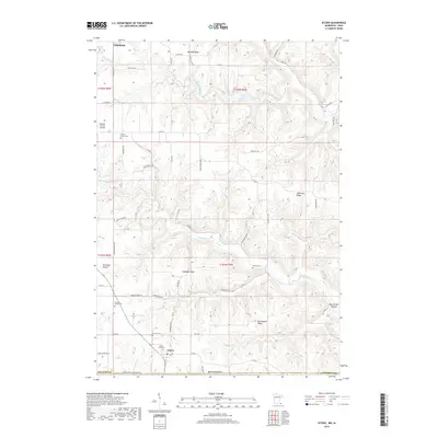
2019 Map of Eitzen
USGS Topo · Published 2019About this map
Eitzen sits at the southern edge of this landscape, just north of Stateline Dr State Line Rd where Houston County meets the Iowa border. The terrain is defined by a dense network of high ridges and deep valleys, including Murphy Ridge and Jefferson Ridge to the north, and the curiously named New Yorker Hollow in the southeast. This geography dictated early settlement and travel patterns, with roads like Cabbage Ridge Dr following the high ground above the drainage of Winnebago Cr. For family historians, the area is rich with small burial grounds such as Saint Lukes Cem, Portland Prairie Cem, and Steele Cem, reflecting the scattered rural communities and church parishes like Portland Prairie that characterized this border region in the late 20th and early 21st centuries.
Find a feature on this map
72 named features on this map. Tap any name to fly to it.
Don’t see what you’re looking for? This feature index may not catch every label — zoom into the map to look around manually.
Map Details
Editions of this 2019 Eitzen Map
This is the sole edition of this map. No revisions or reprints were ever made.
Other maps of this area

1903 · Waukon
USGS Topo · 1:125,000

1906 · Decorah
USGS Topo · 1:125,000

1956 · Brownsville
USGS Topo · 1:62,500

1958 · La Crosse
USGS Topo · 1:250,000

1961 · La Crosse
USGS Topo · 1:250,000

1965 · La Crosse
USGS Topo · 1:250,000

1965 · Wilmington
USGS Topo · 1:24,000

1965 · Sheldon
USGS Topo · 1:24,000
1968 · New Albin
USGS Topo · 1:24,000
1968 · Waukon NW
USGS Topo · 1:24,000