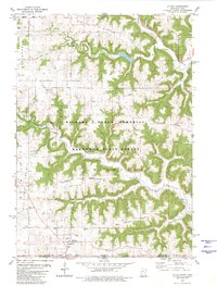
1980 Map of Eitzen
USGS Topo · Published 1980About this map
Eitzen sits at the southern edge of this 1980 survey, straddling the state line where Houston County, Minnesota, meets Allamakee County, Iowa. The landscape is defined by deep dissection, where high plateaus like Portland Prairie give way to a network of steep ridges and valleys, including Murphy Ridge, Jefferson Ridge, and Winnebago Ridge. Much of this terrain is protected within the Richard J Dorer Memorial Hardwood State Forest, preserving the wooded slopes above Winnebago Creek and the South Fork of Crooked Creek.
Find a feature on this map
27 named features on this map. Tap any name to fly to it.
Don’t see what you’re looking for? This feature index may not catch every label — zoom into the map to look around manually.
Map Details
Editions of this 1980 Eitzen Map
This is the sole edition of this map. No revisions or reprints were ever made.
Other maps of this area

1903 · Waukon
USGS Topo · 1:125,000

1906 · Decorah
USGS Topo · 1:125,000

1956 · Brownsville
USGS Topo · 1:62,500

1958 · La Crosse
USGS Topo · 1:250,000

1961 · La Crosse
USGS Topo · 1:250,000

1965 · La Crosse
USGS Topo · 1:250,000

1965 · Wilmington
USGS Topo · 1:24,000

1965 · Sheldon
USGS Topo · 1:24,000
1968 · New Albin
USGS Topo · 1:24,000
1968 · Waukon NW
USGS Topo · 1:24,000