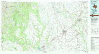
1994 Map of El Campo
USGS Topo · Published 1994About this map
The Colorado River and San Bernard River systems define this 1994 topographic study of the Texas coastal plains. Centered on the industrial and agricultural hub of El Campo, the landscape is a grid of ranch roads, irrigation networks, and extensive energy extraction sites. Numerous production zones like the Sheridan Gas Field and Provident City Gas Field indicate the region's reliance on the petroleum industry during the late 20th century.
Find a feature on this map
88 named features on this map. Tap any name to fly to it.
Don’t see what you’re looking for? This feature index may not catch every label — zoom into the map to look around manually.
Map Details
Editions of this 1994 El Campo Map
This is the sole edition of this map. No revisions or reprints were ever made.
Other maps of this area

1901 · Flatonia
USGS Topo · 1:125,000

1919 · Schulenburg
USGS Topo · 1:62,500

1950 · Houston
USGS Topo · 1:250,000

1951 · Bay City
USGS Topo · 1:250,000

1951 · Inez NW
USGS Topo · 1:24,000

1951 · Danevang
USGS Topo · 1:24,000

1951 · Inez
USGS Topo · 1:24,000

1952 · Francitas NW
USGS Topo · 1:24,000

1952 · Lane City SE
USGS Topo · 1:24,000

1952 · Manson
USGS Topo · 1:24,000