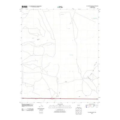
2010 Map of El Cuervo Butte
USGS Topo · Published 2010About this map
El Cuervo Butte stands as the primary landmark in this high-desert portion of Torrance County, New Mexico. The landscape is defined by a sparse settlement pattern characteristic of the region, anchored by the Chavez Ranch and the small communities of El Cuervo and Osita. Arid drainage features, or draws, such as Chavez Draw, Porcupine Draw, and Cupido Draw, dominate the topography, illustrating the complex seasonal hydrology of the area. Water management is evident through scattered stock tanks and small basins like Rock Lake, Dinosaur Tank, and Twin Lakes, which supported ranching operations in the early 21st century. The presence of Frontage Rd running parallel to the interstate corridor at the southern edge highlights the area's modern transportation infrastructure while local routes like County Rd C124 provide access to the interior ranch lands.
Find a feature on this map
13 named features on this map. Tap any name to fly to it.
Don’t see what you’re looking for? This feature index may not catch every label — zoom into the map to look around manually.
Map Details
Editions of this 2010 El Cuervo Butte Map
This is the sole edition of this map. No revisions or reprints were ever made.
Other maps of this area

1894 · Lamy
USGS Topo · 1:125,000

1954 · Santa Fe
USGS Topo · 1:250,000

1954 · Fort Sumner
USGS Topo · 1:250,000

1958 · Fort Sumner
USGS Topo · 1:250,000

1958 · Santa Fe
USGS Topo · 1:250,000

1960 · Lobo Hill
USGS Topo · 1:62,500

1960 · Stanley
USGS Topo · 1:62,500
1966 · Mesa El Toro
USGS Topo · 1:24,000
1966 · Clines Corners
USGS Topo · 1:24,000
1978 · Rock Lake
USGS Topo · 1:24,000