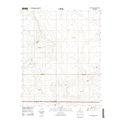
2013 Map of El Cuervo Butte
USGS Topo · Published 2013About this map
El Cuervo Butte dominates this high-altitude landscape along the border of Santa Fe and Torrance counties. The terrain is defined by a series of drainage features including Cupido Draw, Porcupine Draw, and Chavez Draw, which illustrate the arid hydrology of this New Mexico region. Ranching signatures are scattered across the quadrangle, notably at Chavez Ranch and Osita Ranch, suggesting a legacy of livestock operations supported by local water sources like Rock Lake, Dinosaur Tank, and Twin Lakes. In the southern portion of the sheet, the Wagon Wheel Interchange on Interstate 40 serves as the primary modern transportation artery, connecting local routes like B Anaya Rd and Co Road 128 to the regional network. This survey preserves a transition point where the high plains meet the elevated volcanic features of the Estancia Valley.
Find a feature on this map
21 named features on this map. Tap any name to fly to it.
Don’t see what you’re looking for? This feature index may not catch every label — zoom into the map to look around manually.
Map Details
Editions of this 2013 El Cuervo Butte Map
This is the sole edition of this map. No revisions or reprints were ever made.
Other maps of this area
1894 · Lamy
USGS Topo · 1:125,000
1954 · Santa Fe
USGS Topo · 1:250,000
1954 · Fort Sumner
USGS Topo · 1:250,000
1958 · Fort Sumner
USGS Topo · 1:250,000
1958 · Santa Fe
USGS Topo · 1:250,000
1960 · Lobo Hill
USGS Topo · 1:62,500
1960 · Stanley
USGS Topo · 1:62,500
1966 · Mesa El Toro
USGS Topo · 1:24,000
1966 · Clines Corners
USGS Topo · 1:24,000
1978 · Rock Lake
USGS Topo · 1:24,000