1989 Map of El Dorado
USGS Topo · Published 1990About this map
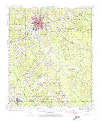
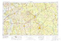
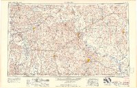
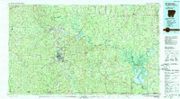
The Ouachita River and its massive Felsenthal Pool dominate the southeastern landscape of this late-twentieth-century study of Southern Arkansas and the Louisiana borderlands. This region, defined by the Gulf Coastal Plain, shows a complex network of water and timber management, with large-scale features like the Felsenthal National Wildlife Refuge and Poison Springs State Forest preserving significant acreage. The settlement pattern is anchored by regional hubs such as El Dorado, Camden, and Magnolia, connected by a mature highway system including U.S. 82 and Interstate 30.
Find a feature on this map
116 named features on this map. Tap any name to fly to it.
Don’t see what you’re looking for? This feature index may not catch every label — zoom into the map to look around manually.
Map Details
Editions of this 1989 El Dorado Map
This is the sole edition of this map. No revisions or reprints were ever made.
Historical Maps of Texarkana Through Time
9 maps found