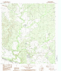
1983 Map of El Indio
USGS Topo · Published 1983About this map
El Indio serves as the focal point of this 1983 borderland survey, situated on the banks where the Rio Grande meets the international boundary between the United States of America and Estados Unidos Mexicanos. The landscape is defined by the vital water management systems of the era, most notably the Maverick Canal and a network of irrigation ditches that snake through the terrain. These engineering features reflect the agricultural dependency of the region, drawing from the river to support local development. The drainage patterns of Mule Creek, Saus Creek, and Cuevas Creek carve through the topography, leading toward the river valley. On the Mexican side, the river is also identified as the Rio Bravo, highlighting the dual nomenclature of this shared waterway. Local watering points like Beaver Tank are noted, providing insight into the rural land use and livestock management practices in this part of Maverick County during the early 1980s.
Find a feature on this map
13 named features on this map. Tap any name to fly to it.
Don’t see what you’re looking for? This feature index may not catch every label — zoom into the map to look around manually.
Map Details
Editions of this 1983 El Indio Map
This is the sole edition of this map. No revisions or reprints were ever made.
Other maps of this area

1940 · Cometa
USGS Topo · 1:62,500

1940 · Eagle Pass
USGS Topo · 1:62,500

1941 · Botella Creek
USGS Topo · 1:62,500

1957 · Indio Creek
USGS Topo · 1:62,500

1957 · Botella Creek
USGS Topo · 1:62,500

1958 · Eagle Pass
USGS Topo · 1:250,000

1965 · Eagle Pass
USGS Topo · 1:250,000
1974 · Sacatosa Tank
USGS Topo · 1:24,000
1982 · Indio Tank
USGS Topo · 1:24,000
1982 · Eagle Pass NE
USGS Topo · 1:24,000