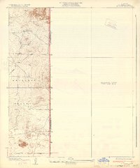
1933 Map of El Mirage
USGS Topo · Published 1933About this map
Antelope Valley occupies this landscape in the early 1930s, revealing a sparsely settled frontier along the border of Los Angeles and San Bernardino Counties. At this time, the area is characterized by high-desert terrain and emerging infrastructure. A singular hub of activity is noted at Walton Place, which stands as a key landmark in this largely open stretch of the high desert. The transportation network is defined by early thoroughfares like El Mirage Road and Avenue P, showing the grid-like progression of surveying into the valley. Water remains the critical resource for the few residents here, evidenced by a solitary Well marked on the sheet. This preliminary edition captures the region as it was transitioning from an unsurveyed frontier to a structured county landscape, with numerous bench marks like BM 2945 and BM 3030 indicating the active work of surveyors J.E. Rockhold and C.P. McKinley.
Find a feature on this map
14 named features on this map. Tap any name to fly to it.
Don’t see what you’re looking for? This feature index may not catch every label — zoom into the map to look around manually.
Map Details
Editions of this 1933 El Mirage Map
2 editions found
Other maps of this area

1930 · Black Butte
USGS Topo · 1:24,000

1930 · El Mirage
USGS Topo · 1:24,000

1930 · Angle
USGS Topo · 1:24,000

1930 · Wilsona
USGS Topo · 1:24,000

1931 · Adobe
USGS Topo · 1:24,000

1931 · Hi Vista
USGS Topo · 1:24,000

1932 · Angle
USGS Topo · 1:24,000

1933 · El Mirage
USGS Topo · 1:24,000

1933 · Black Butte
USGS Topo · 1:24,000

1934 · Adobe
USGS Topo · 1:24,000