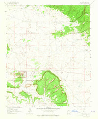
1963 Map of El Morro
USGS Topo · Published 1965About this map
El Morro National Monument dominates this mid-century landscape, preserving the massive sandstone promontory known as Inscription Rock. This survey documents a high-desert environment where ancient and modern human history intersect near the Zuni Mountains. Beyond the monument, the map reveals archaeological traces such as Pueblito (Ruins) and other Pueblo Ruins, alongside the site of Tinaja. The terrain transitions from the high elevations of the Cibola National Forest in the northeast to prominent landforms like Obe Worthen Mesa and Charlie Barns Gap in the south. Settlement is sparse, represented by small points like Sand Corner and the village of El Morro, reflecting a rugged region defined more by its geology and historical inscriptions than by industrial development. Ephemeral water sources like Caruco Spring and Canoncito highlight the essential nature of water in this arid stretch of New Mexico.
Find a feature on this map
23 named features on this map. Tap any name to fly to it.
Don’t see what you’re looking for? This feature index may not catch every label — zoom into the map to look around manually.
Map Details
Editions of this 1963 El Morro Map
3 editions found
Other maps of this area

1886 · Wingate
USGS Topo · 1:250,000

1892 · Wingate
USGS Topo · 1:250,000

1952 · Valle Largo
USGS Topo · 1:24,000

1952 · Post Office Flat
USGS Topo · 1:24,000

1954 · Saint Johns
USGS Topo · 1:250,000

1954 · Gallup
USGS Topo · 1:250,000

1957 · Saint Johns
USGS Topo · 1:250,000

1958 · Gallup
USGS Topo · 1:250,000

1958 · Saint Johns
USGS Topo · 1:250,000

1959 · Gallup
USGS Topo · 1:250,000
Featured Places
- Eastern Navajo Agency, NM
- Sand Corner, Eastern Navajo Agency
- Tinaja, Eastern Navajo Agency
- El Morro, Eastern Navajo Agency
- El Morro, Eastern Navajo Agency