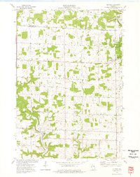
1974 Map of El Paso
USGS Topo · Published 1977About this map
The Rush River valley defines the southwest corner of this Pierce County landscape, where the settlement of El Paso sits at the confluence of several steep coulees. This 1970s survey captures a rural terrain shaped by its hydrology and transportation history, featuring an abandoned Railroad Grade running north towards the Eau Galle River in the township of Eau Galle. Local social centers are clearly marked, including the Gilman Sch and the Gilman Ch near the center of the sheet, alongside the community of Olivet to the east.
Find a feature on this map
26 named features on this map. Tap any name to fly to it.
Don’t see what you’re looking for? This feature index may not catch every label — zoom into the map to look around manually.
Map Details
Editions of this 1974 El Paso Map
This is the sole edition of this map. No revisions or reprints were ever made.
Other maps of this area

1935 · Arkansaw
USGS Topo · 1:48,000

1940 · Maiden Rock
USGS Topo · 1:62,500

1941 · Arkansaw
USGS Topo · 1:62,500

1942 · Arkansaw
USGS Topo · 1:62,500

1946 · Knapp
USGS Topo · 1:62,500

1949 · Knapp
USGS Topo · 1:62,500

1949 · Baldwin
USGS Topo · 1:62,500

1950 · Maiden Rock
USGS Topo · 1:62,500

1953 · Saint Paul
USGS Topo · 1:250,000

1959 · Saint Paul
USGS Topo · 1:250,000