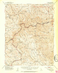
1947 Map of El Portal
USGS Topo · Published 1953About this map
The Merced River canyon serves as the central artery for this 1947 topographical study, where the All-Year Highway snakes through steep Sierra foothills. This era captures the transition from early mining and stagecoach travel to modern mountain tourism, with the McCauley Ranch (Old Stage Sta) and Incline marking older routes of commerce. High-altitude groves like the Merced Grove Big Trees stand near the park boundary, while the landscape below is dotted with active and legacy mining operations, including the Schroeder Mine and King Solomon Mine.
Find a feature on this map
101 named features on this map. Tap any name to fly to it.
Don’t see what you’re looking for? This feature index may not catch every label — zoom into the map to look around manually.
Map Details
Editions of this 1947 El Portal Map
4 editions found

Other maps of this area

1893 · Sonora
USGS Topo · 1:125,000

1896 · Sonora
USGS Topo · 1:125,000

1897 · Sonora
USGS Topo · 1:125,000

1897 · Yosemite
USGS Topo · 1:125,000

1898 · Sonora
USGS Topo · 1:125,000

1900 · Yosemite
USGS Topo · 1:125,000

1903 · Yosemite
USGS Topo · 1:125,000

1909 · Yosemite
USGS Topo · 1:125,000

1912 · Mariposa
USGS Topo · 1:125,000

1919 · Indian Gulch
USGS Topo · 1:48,000