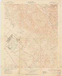
1950 Map of El Toro
USGS Topo · Published 1950About this map
The El Toro Naval Air Station Reservation dominates the southwestern lowlands of this mid-century Orange County landscape, appearing here just years after its wartime expansion. This sprawling military facility is bisected by the Atchison Topeka and Sante Fe railroad and surrounded by citrus groves and agricultural tracts like Serrano Place. To the northeast, the terrain rises sharply into the Lomas de Santiago and the foothills of the Cleveland National Forest, where canyon life is centered around the settlements of Silverado and Modjeska.
Find a feature on this map
41 named features on this map. Tap any name to fly to it.
Don’t see what you’re looking for? This feature index may not catch every label — zoom into the map to look around manually.
Map Details
Editions of this 1950 El Toro Map
2 editions found
Other maps of this area

1896 · Santa Ana
USGS Topo · 1:62,500

1896 · Anaheim
USGS Topo · 1:62,500

1898 · Anaheim
USGS Topo · 1:62,500

1901 · Southern California Sheet No. 1
USGS Topo · 1:250,000

1901 · Santa Ana
USGS Topo · 1:62,500

1901 · Anaheim
USGS Topo · 1:62,500

1902 · Corona
USGS Topo · 1:125,000

1904 · Southern California Sheet No. 1
USGS Topo · 1:250,000

1932 · Orange
USGS Topo · 1:31,680

1932 · Tustin
USGS Topo · 1:31,680