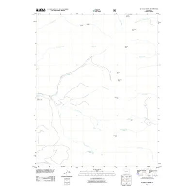
2011 Map of El Valle Creek
USGS Topo · Published 2011About this map
Whiskey Pass serves as a central high-altitude crossing in this portion of the Sangre de Cristo Mountains, where Whiskey Pass Rd winds through a landscape defined by prominent summits and alpine drainage systems. The map detail highlights a series of significant peaks, including Mount Maxwell, De Anza Peak, and Francisco Peak, which form a dramatic spine above the headwaters of numerous creeks. Water management is evidenced at the western edge by the Salazar Number 2 Dam along Culebra Creek. The network of waterways is extensive, with El Valle Creek and El Perdido Creek flowing through deep canyons like Canova Canyon. Toward the southern reaches, isolated water bodies such as Lost Lake, Strawberry Lake, and Carneros Lake sit at the base of Miranda Peak, illustrating the high-elevation hydrology typical of the Las Animas County high country.
Find a feature on this map
28 named features on this map. Tap any name to fly to it.
Don’t see what you’re looking for? This feature index may not catch every label — zoom into the map to look around manually.
Map Details
Editions of this 2011 El Valle Creek Map
This is the sole edition of this map. No revisions or reprints were ever made.
Other maps of this area

1954 · Trinidad
USGS Topo · 1:250,000

1955 · Trinidad
USGS Topo · 1:250,000

1958 · Trinidad
USGS Topo · 1:250,000
1959 · Trinidad
USGS Topo · 1:250,000
1967 · La Valley
USGS Topo · 1:24,000
1967 · Ojito Peak
USGS Topo · 1:24,000
1967 · Cucharas Pass
USGS Topo · 1:24,000
1967 · Taylor Ranch
USGS Topo · 1:24,000
1967 · Stonewall
USGS Topo · 1:24,000
1967 · Culebra Peak
USGS Topo · 1:24,000