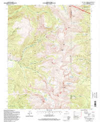
1994 Map of El Valle Creek
USGS Topo · Published 1998About this map
The high alpine crest of the Sangre De Cristo Mountains dominates this mid-1990s study, where the peaks form a natural divide between Costilla and Las Animas counties. The landscape is defined by the steep descent of glacial drainage basins, including the headwaters of El Valle Creek and Culebra Creek to the west, and the North Fork Purgatoire River to the northeast. High-altitude water bodies such as Lost Lake, Strawberry Lake, and Carneros Lake are tucked into the basins below towering summits like Mount Maxwell and De Anza Peak.
Find a feature on this map
38 named features on this map. Tap any name to fly to it.
Don’t see what you’re looking for? This feature index may not catch every label — zoom into the map to look around manually.
Map Details
Editions of this 1994 El Valle Creek Map
This is the sole edition of this map. No revisions or reprints were ever made.
Other maps of this area

1954 · Trinidad
USGS Topo · 1:250,000

1955 · Trinidad
USGS Topo · 1:250,000

1958 · Trinidad
USGS Topo · 1:250,000

1959 · Trinidad
USGS Topo · 1:250,000

1967 · La Valley
USGS Topo · 1:24,000

1967 · Ojito Peak
USGS Topo · 1:24,000
1967 · Cucharas Pass
USGS Topo · 1:24,000

1967 · Taylor Ranch
USGS Topo · 1:24,000
1967 · Stonewall
USGS Topo · 1:24,000
1967 · Culebra Peak
USGS Topo · 1:24,000