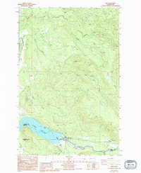
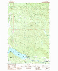
1987 Map of Elbe
USGS Topo · Published 1994About this map
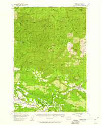
Elbe sits at a critical geographic crossroads where the Nisqually River meets the eastern reaches of Alder Lake. This survey captures the intricate drainage patterns of the southern Cascades foothills, dominated by the Mashel River and Little Mashel River systems as they carve through the timbered landscape near Dobbs Mountain. The settlement at Park Junction and the adjacent Pleasant Valley represent the primary areas of human activity, linked by a network of roads and 4wd trails that navigate the steep topography. Numerous Borrow Pits and a Gravel Pit scattered across the ridges suggest an economy tied to forest management and infrastructure maintenance during the late 20th century. The map also delineates the meeting point of three counties—Pierce, Thurston, and Lewis—illustrating how the Nisqually River serves as a natural political boundary in this portion of Washington.
Find a feature on this map
23 named features on this map. Tap any name to fly to it.
Don’t see what you’re looking for? This feature index may not catch every label — zoom into the map to look around manually.
Map Details
Editions of this 1987 Elbe Map
2 editions found
Other maps of this area

1937 · Eatonville
USGS Topo · 1:125,000

1941 · Tanwax Lake
USGS Topo · 1:62,500

1944 · Ohop Valley
USGS Topo · 1:62,500

1949 · Ohop Valley
USGS Topo · 1:62,500

1953 · Hoquiam
USGS Topo · 1:250,000
1956 · Mineral
USGS Topo · 1:62,500
1956 · Kapowsin
USGS Topo · 1:62,500

1957 · Hoquiam
USGS Topo · 1:250,000
1957 · Morton
USGS Topo · 1:62,500

1958 · Hoquiam
USGS Topo · 1:250,000