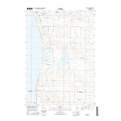
2014 Map of Elberta
USGS Topo · Published 2014About this map
Betsie Lake and the coastal village of Elberta dominate the northwestern shoreline of this Benzie County landscape, where the Betsie River meets the waters of Lake Michigan. The topography reveals a complex network of coastal dunes and inland basins, including the significant waters of Upper Herring Lake and Lower Herring Lake near the settlement of Watervale. This 2014 representation details the inland reach of the Frankfort Dow Memorial Field Airport and several local burial grounds, such as Gilmore Township Cem and Blaine Cem, which serve as vital landmarks for genealogical research. To the south, the terrain rises toward Inspiration Point before descending into Arcadia, illustrating the transition across the Manistee County line through a landscape defined by creeks like Herring Cr and Dooley Cr.
Find a feature on this map
71 named features on this map. Tap any name to fly to it.
Don’t see what you’re looking for? This feature index may not catch every label — zoom into the map to look around manually.
Map Details
Editions of this 2014 Elberta Map
This is the sole edition of this map. No revisions or reprints were ever made.
Other maps of this area

1954 · Manitowoc
USGS Topo · 1:250,000

1956 · Onekama
USGS Topo · 1:62,500

1956 · Bar Lake
USGS Topo · 1:62,500

1956 · Frankfort
USGS Topo · 1:62,500

1958 · Manitowoc
USGS Topo · 1:250,000

1976 · Frankfort SE
USGS Topo · 1:24,000

1976 · Frankfort NW
USGS Topo · 1:24,000

1976 · Frankfort SW
USGS Topo · 1:24,000

1976 · Onekama NW
USGS Topo · 1:24,000
1976 · Frankfort NE
USGS Topo · 1:24,000