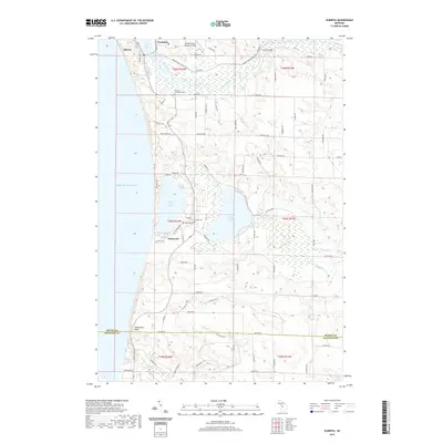
2019 Map of Elberta
USGS Topo · Published 2019About this map
Elberta and Frankfort sit at the northern edge of this coastal landscape, separated by the waters of Betsie Lake where the Betsie River meets Lake Michigan. The region is defined by its dramatic shoreline and significant elevation changes, notably at Inspiration Point and the Arcadia Dunes area near the Benzie and Manistee county line. Moving inland, the landscape transitions from open dunes and coastal bluffs to a series of freshwater bodies, including Lower Herring Lake and Upper Herring Lake. Local history and genealogy are anchored by sites such as the Gilmore Township Cem and Blaine Cem, while the Betsie Valley State Trail follows a former rail corridor through the river valley. The map also documents aviation and local transport hubs like Frankfort Dow Memorial Field and the settlement of Watervale further south along the coast.
Find a feature on this map
85 named features on this map. Tap any name to fly to it.
Don’t see what you’re looking for? This feature index may not catch every label — zoom into the map to look around manually.
Map Details
Editions of this 2019 Elberta Map
This is the sole edition of this map. No revisions or reprints were ever made.
Other maps of this area

1954 · Manitowoc
USGS Topo · 1:250,000

1956 · Onekama
USGS Topo · 1:62,500

1956 · Bar Lake
USGS Topo · 1:62,500

1956 · Frankfort
USGS Topo · 1:62,500

1958 · Manitowoc
USGS Topo · 1:250,000

1976 · Frankfort SE
USGS Topo · 1:24,000

1976 · Frankfort NW
USGS Topo · 1:24,000

1976 · Frankfort SW
USGS Topo · 1:24,000

1976 · Onekama NW
USGS Topo · 1:24,000
1976 · Frankfort NE
USGS Topo · 1:24,000