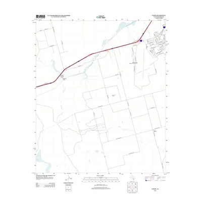
2012 Map of Elbow
USGS Topo · Published 2012About this map
The West Texas landscape south of Big Spring is defined by its industrial and educational infrastructure. The Big Spring Mc Mahon-Wrinkle Airport and the campus of the Southwest Collegiate Institute For The Deaf occupy the former Webb Air Force Base grounds, showing the repurposing of military facilities for specialized education and regional aviation. This 2012 survey illustrates a patchwork of utility and agriculture, with the Moore Oil Field indicating the persistent role of energy extraction in Howard County.
Find a feature on this map
58 named features on this map. Tap any name to fly to it.
Don’t see what you’re looking for? This feature index may not catch every label — zoom into the map to look around manually.
Map Details
Editions of this 2012 Elbow Map
This is the sole edition of this map. No revisions or reprints were ever made.
Other maps of this area

1941 · Morita
USGS Topo · 1:62,500

1941 · Big Spring South
USGS Topo · 1:62,500

1942 · Big Spring South
USGS Topo · 1:62,500

1942 · Big Spring North
USGS Topo · 1:62,500

1949 · Morita
USGS Topo · 1:62,500

1954 · Big Spring
USGS Topo · 1:250,000

1954 · Big Spring North
USGS Topo · 1:24,000

1958 · Big Spring
USGS Topo · 1:250,000

1965 · Big Spring North
USGS Topo · 1:24,000
1966 · Lucian Wells Ranch
USGS Topo · 1:24,000