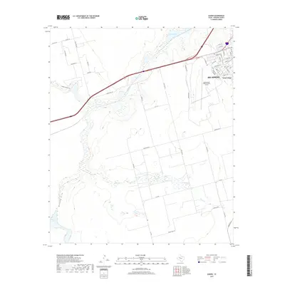
2019 Map of Elbow
USGS Topo · Published 2019About this map
Big Spring anchors the northeastern corner of this West Texas landscape, showing the expansion of residential streets like Bethel Dr and Mesquite St alongside the regional aviation hub at Big Spring Mc Mahon-Wrinkle Airport. The terrain is defined by a series of intermittent draws and alkaline water features typical of the Llano Estacado. To the west, the winding paths of Mustang Draw and Sulphur Springs Draw converge toward Roberts Lake, while Salt Lake sits centrally along the course of Beals Cr. The map details the transition from the organized street grid of Webb Village to the broad rural expanses of Howard County, interconnected by a network of ranch roads including Cauble Rd and Ranch Rd 2599. This documentation illustrates the intersection of industrial aviation, municipal growth, and the natural drainage systems that dictate the layout of the Texas plains.
Find a feature on this map
53 named features on this map. Tap any name to fly to it.
Don’t see what you’re looking for? This feature index may not catch every label — zoom into the map to look around manually.
Map Details
Editions of this 2019 Elbow Map
This is the sole edition of this map. No revisions or reprints were ever made.
Other maps of this area

1941 · Morita
USGS Topo · 1:62,500

1941 · Big Spring South
USGS Topo · 1:62,500

1942 · Big Spring South
USGS Topo · 1:62,500

1942 · Big Spring North
USGS Topo · 1:62,500

1949 · Morita
USGS Topo · 1:62,500

1954 · Big Spring
USGS Topo · 1:250,000

1954 · Big Spring North
USGS Topo · 1:24,000

1958 · Big Spring
USGS Topo · 1:250,000

1965 · Big Spring North
USGS Topo · 1:24,000
1966 · Lucian Wells Ranch
USGS Topo · 1:24,000