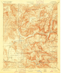
1903 Map of Elcajon
USGS Topo · Published 1916About this map
Elcajon Valley serves as the focal point for this early twentieth-century survey, illustrating a landscape defined by water management and early rail transport. The San Diego Flume winds through the hills, a critical engineering feat designed to carry water to the coastal settlements, while several mountain tunnels, including the Cape Horn Tunnel and Lankersheim Tunnel, mark the rugged ascent east of the valley. The terminal rail line of the San Diego Cuyamaca and Eastern Railroad concludes at Foster, highlighting the era's limits of steam-powered infrastructure before the widespread adoption of the automobile. Cultural boundaries are clearly delineated, featuring the Capitan Grande Indian Reservation and Sequan Indian Reservation, alongside established valley floor towns like Lakeside and Bostonia. This document records the transition of the region from open ranch lands to organized agricultural and residential hubs.
Find a feature on this map
52 named features on this map. Tap any name to fly to it.
Don’t see what you’re looking for? This feature index may not catch every label — zoom into the map to look around manually.
Map Details
Editions of this 1903 Elcajon Map
5 editions found
Other maps of this area

1893 · El Cajon
USGS Topo · 1:62,500

1893 · Escondido
USGS Topo · 1:62,500

1901 · Elcajon
USGS Topo · 1:62,500

1901 · Escondido
USGS Topo · 1:62,500

1901 · San Luis Rey
USGS Topo · 1:125,000

1903 · Cuyamaca
USGS Topo · 1:125,000

1903 · La Jolla
USGS Topo · 1:62,500

1903 · Elcajon
USGS Topo · 1:62,500

1903 · Ramona
USGS Topo · 1:125,000

1904 · San Diego
USGS Topo · 1:62,500