
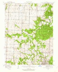
1939 Map of Eldorado Springs North
USGS Topo · Published 1959About this map
Eldorado Springs anchors the southeastern corner of this landscape, where the Court House and Community Bldg stand as central landmarks in the early twentieth century. The surrounding countryside is defined by a dense network of rural infrastructure, including many family-named schools and churches that served the agricultural community. To the northwest, the settlement of Portia and the Lefler Cem provide valuable touchpoints for genealogical research. The terrain is deeply etched by the winding course of Clear Creek and its many tributaries, such as Kitten Creek and Walnut Creek. This 1930s survey, conducted by Daniel Kennedy and his team, shows a high density of one-room schoolhouses like Prairie Valley Sch and Oak Ridge Sch, illustrating the dispersed pattern of rural life before the mid-century consolidation of school districts in Missouri.
Find a feature on this map
31 named features on this map. Tap any name to fly to it.
Don’t see what you’re looking for? This feature index may not catch every label — zoom into the map to look around manually.
Map Details
Editions of this 1939 Eldorado Springs North Map
2 editions found
Other maps of this area

1886 · Nevada
USGS Topo · 1:125,000

1886 · Stockton
USGS Topo · 1:125,000

1887 · Clinton
USGS Topo · 1:125,000

1887 · Butler
USGS Topo · 1:125,000

1894 · Butler
USGS Topo · 1:125,000

1894 · Nevada
USGS Topo · 1:125,000

1894 · Clinton
USGS Topo · 1:125,000

1934 · Papinsville
USGS Topo · 1:24,000

1934 · Rockville
USGS Topo · 1:24,000

1937 · Tiffin
USGS Topo · 1:31,680