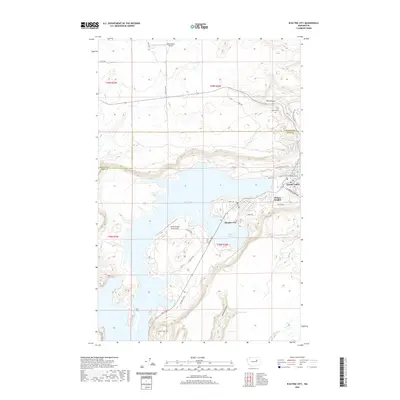
2020 Map of Electric City
USGS Topo · Published 2020About this map
Banks Lake and its intricate shoreline dominate this modern landscape where the coulee floor was transformed into a massive reservoir. The residential grids of Electric City and Delano Heights sit adjacent to the lake’s eastern edge, while the town of Grand Coulee is perched further north near the essential infrastructure of the dam. The surrounding terrain is marked by prominent geological features such as Castle Rock, Eagle Rock, and Fiddle Butte, which rise above the water and canyon floors. Transportation and aviation are represented by the Grand Coulee Dam Airport and Rice Ranch Airport, serving this hub of the Columbia Basin. To the south, smaller water bodies like Osborn Bay Lake, Northrup Lake, and Fish Lake appear within the protected corridor of the canyon, while Wallace Canyon cuts into the high ground to the northeast, illustrating the dramatic elevation changes that characterize this part of Grant and Douglas counties.
Find a feature on this map
35 named features on this map. Tap any name to fly to it.
Don’t see what you’re looking for? This feature index may not catch every label — zoom into the map to look around manually.
Map Details
Editions of this 2020 Electric City Map
This is the sole edition of this map. No revisions or reprints were ever made.
Other maps of this area

1948 · Grand Coulee Dam
USGS Topo · 1:62,500

1950 · Grand Coulee Dam
USGS Topo · 1:62,500

1950 · Nespelem
USGS Topo · 1:62,500

1950 · Alameda Flat
USGS Topo · 1:62,500

1952 · Alameda Flat
USGS Topo · 1:62,500

1953 · Ritzville
USGS Topo · 1:250,000

1954 · Okanogan
USGS Topo · 1:250,000

1958 · Okanogan
USGS Topo · 1:250,000

1959 · Ritzville
USGS Topo · 1:250,000

1965 · Ritzville
USGS Topo · 1:250,000