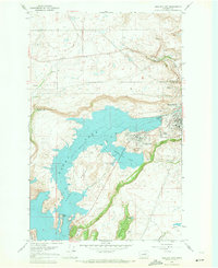
1968 Map of Electric City
USGS Topo · Published 1971About this map
Electric City and its neighbor Grand Coulee define the human footprint on this high desert plateau in the late 1960s, overlooking the engineered waters of the Columbia Basin Project. The landscape is dominated by the massive reservoir of Banks Lake and the Upper Grand Coulee Lake, held in place by the North Dam. This survey documents a critical period of water management, showing the submerged contours mapped by the U.S. Bureau of Reclamation. Beyond the residential clusters of Delano Heights and the small Electric City Airport, the terrain rises toward dramatic basalt features like Steamboat Rock and Eagle Rock. The map illustrates the industrial utility of the region, where numerous borrow pits and gravel pits support local infrastructure alongside prominent geological landmarks like Northrup Canyon and Castle Rock.
Find a feature on this map
27 named features on this map. Tap any name to fly to it.
Don’t see what you’re looking for? This feature index may not catch every label — zoom into the map to look around manually.
Map Details
Editions of this 1968 Electric City Map
This is the sole edition of this map. No revisions or reprints were ever made.
Other maps of this area

1948 · Grand Coulee Dam
USGS Topo · 1:62,500

1950 · Grand Coulee Dam
USGS Topo · 1:62,500

1950 · Nespelem
USGS Topo · 1:62,500

1950 · Alameda Flat
USGS Topo · 1:62,500

1952 · Alameda Flat
USGS Topo · 1:62,500

1953 · Ritzville
USGS Topo · 1:250,000

1954 · Okanogan
USGS Topo · 1:250,000

1958 · Okanogan
USGS Topo · 1:250,000

1959 · Ritzville
USGS Topo · 1:250,000

1965 · Ritzville
USGS Topo · 1:250,000